Archives
Enter a word or phrase to perform a general search across all records in the Archives catalog. You can also browse records in the catalog without performing a search.
Search Tips
- Searches are not case sensitive.
- Searching for multiple words connects them with OR by default. Matching records can contain any of the words.
- Connect multiple words with AND if you only want to see records containing both words.
- Use quotation marks to search for a phrase.
- Place an asterisk (*) at the end of a word as a wildcard.
390 results found. Records searched: 390
-
193.503.0312 - Map
D.L.& W. RR CO.; PELOUBET ESTATE; W.S.& A. TRACTION CO.;Wm. TEW;THE REST CEMETERY
Record Type: Archive
-
-
-
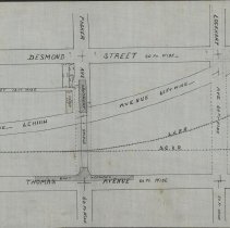
193.503.0315 - Map
DESMOND STREET;HAYDEN STREET;LEHIGH AVENUE; LOCKARD AVENUE;PACKER AVENUE;THOMAS AVENUE;'CAREY';
Record Type: Archive
-
193.503.0316 - Map
CHEMUNG STREET; EAST STREET;HAYDEN STREET;RIVER STREET;LEHIGH AVENUE; LOCKARDSTREET;PACKER AVENUE;THOMAS AVENUE;HIRAM THOMAS FARM;MARY DORAN;JOEL HULETT;A.B.SHEARER;
Record Type: Archive
-
-
-
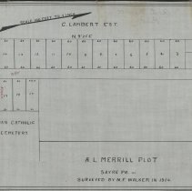
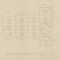
193.503.0336 - Map
ROMAN CATHOLIC CEMETERY, B.F.HORTON, C. LAMBERT ESTATE, J.WESTBROOK, CENTER STREET, LOCKHART STREET,
Record Type: Archive
-
193.503.0337 - Map
MURPHY,HIGHLAND AVENUE, PENNSYLVANIA AVENUE, WARREN STREET, MARY LYNCH'S LOTS
Record Type: Archive
-
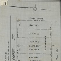
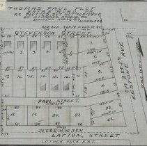
193.503.0338 - Map
LUTHER PECK ESTATE, KEYSTONE AVENUE, LAYTON STREET, PAUL STREET,STEVENSON STREET, THOMAS PAUL PLOT, PLOTTED BOUT NOT SURVEYED
Record Type: Archive
-
193.503.0339 - Map
CLARKE FARM, WESTBROOK FARM, PAT LYNCH, M.J.MURRAY, HIGHLAND AVENUE, LEWIS STREET, PENNSYLVANIA AVENUE, POPLAR STREET,EAST FOURTH STREET, WARREN STREET, LYNCH PLOT
Record Type: Archive
-
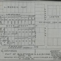
193.503.0340 - Map
L. DUBOIS PLOT, REV. LUTHER PECK ESTATE, JACOB G. WESTBROOK, LAMBERT ESTATE, DEWITT OLMSTEAD, ALEX W. STEDMAN, WATLER T. STEDMAN, CHARLES STEDMAN, MARY S. WELLS, MARGARETTA COMPTON, LAMBAERT STREET,LAYTON STREET, LOCKHART STREET, PECK STREET, PENNSYLVANIA AVENUE, WEST STREET,
Record Type: Archive
-
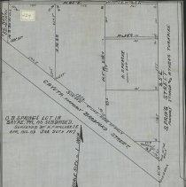
193.503.0341 - Map
DORR PARK, JOHN HENSLEY,PATRICK HURLEY, DENNIS McCARTY,DANIEL MURPHY,DANIEL McDUFFEY, IRA SHERWOOD, JULIUS TOZER, TIMOTHY OBRIEN, RIVER ROAD, CHEMUNG RIVER, O'BRIEN CORNERS
Record Type: Archive
-
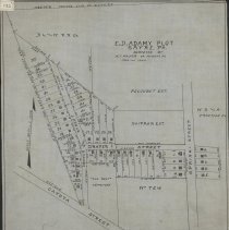
193.503.0342 - Map
MAY KLINE, H. PIOLET, HESTER PIOLET, PRESBYTERIAN CHURCH, DESMOND STREET, ELMER AVENUE, HAYDEN STREET, PACKER AVENUE,
Record Type: Archive
-
1942.501.0001 - Map
Map of the Carroll track in Athens and Ridgeberry Twp containing 12,768 acres and allowance copied from offical maps as filed in the land office of Penna April 15, 1880 Z F Walker C E Wilson Carroll Willing Erwin Hewes
Record Type: Archive
-
1942.501.0013 - Map
Map of the N. B. Canal through the Cash Lockwood Farm 1858 Z F Walker
Record Type: Archive
-
1942.501.0025 - Map
Map showing the settlers of the Old Town of Claverack One of the 17 original Connecticut Townships. This is the area of present day Towanda And Wysox
Record Type: Archive
-
-
-
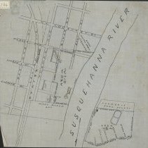
1942.501.0083 - Map
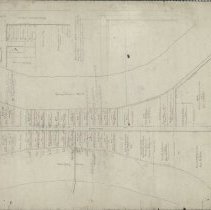
Properties with c.1776 patent owners & subsequent owners between the Chemung River & the Susquehanna River with Chemung Street [Water Street] to the north and Welles Farm to the south, also showing an inset of a Z.F.W. resurvey of an 1868 Patrick's Block survey. Lot numbers 9-46 - same lots also numbered 192-229, with lots south of these numbered 1, 1, 44, and 44. Includes Pine Street, Ferry Street, Main Street, Patrick's Block, Academy Square,...
Record Type: Archive